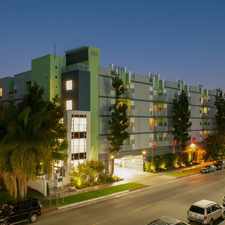
1011 Johnston Street
Lincoln Heights, Los Angeles, 90031
Commute to Downtown East Los Angeles
Most errands can be accomplished on foot.
Many nearby public transportation options.
Flat as a pancake, excellent bike lanes.
About your score
1011 Johnston Street has a Walk Score of 83 out of 100. This location is Very Walkable so most errands can be accomplished on foot.
This location is in the Lincoln Heights neighborhood in Los Angeles. Nearby parks include El Parque De Mexico, Lincoln Park and Lincoln Park.
Explore how far you can travel by car, bus, bike and foot from 1011 Johnston Street.
1011 Johnston Street has good transit which means many nearby public transportation options. Car sharing is available from RelayRides.
Rail lines:
Metro Gold Line (804)
1.3 mi
Orange County Line
1.5 mi
Riverside Line
1.5 mi
Antelope Valley Line
1.5 mi
San Bernardino Line
1.5 mi
Ventura County Line
1.5 mi
91/PVL 91/Perris Valley Line
1.5 mi
Metro Red Line (802)
1.5 mi
Metro Purple Line (805)
1.5 mi
Bus lines:
76 Metro Local Line
0.1 mi
620 Metro Local Line
0.2 mi
78/79/378 Metro Local Line
0.2 mi
605 Metro Local Line
0.2 mi
251 Metro Local Line
0.3 mi
751 Metro Rapid Line
0.3 mi
Car shares:
1011 Johnston Street is in the Lincoln Heights neighborhood. Lincoln Heights is the 26th most walkable neighborhood in Los Angeles with a neighborhood Walk Score of 76.
Moving to Los Angeles from another city? View our moving to Los Angeles guide.


If you are using a screen reader or having trouble reading this website, please call Walk Score customer service at (253) 256-1634.
© 2024 Walk Score