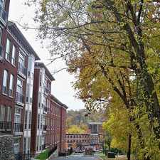
231 Delmar Street
Most errands require a car.
A few nearby public transportation options.
Very steep hills, some bike lanes.
Score Details
231 Delmar Street has a Walk Score of 47 out of 100. This location is a Car-Dependent neighborhood so most errands require a car.
231 Delmar Street is a 11 minute walk from the Manayunk/Norristown Line Manayunk/Norristown Line at the Ivy Ridge stop.
This location is in the Roxborough neighborhood in Philadelphia. Nearby parks include Gorgas Park, Pretzel Park and Manayunk Park.
Explore how far you can travel by car, bus, bike and foot from 231 Delmar Street.
231 Delmar Street has some transit which means a few nearby public transportation options. Car sharing is available from Zipcar.
Rail lines:
Manayunk/Norristown Line Manayunk/Norristown Line
0.3 mi
Bus lines:
35 Manayunk Roxborough Loop
0.2 mi
62 9th-Market to Andorra
0.2 mi
61 9th-Market to Manayunk
0.4 mi
32 Broad-Carpenter to Ridge-Lyceum
0.4 mi
Car shares:
231 Delmar Street compared to all of Philadelphia.
Lowest crime area.
Lowest crime area.
How do you feel walking near 231 Delmar Street?
Day:
Night:
Thanks for your feedback!
231 Delmar Street is in the Roxborough neighborhood. Roxborough is the 59th most walkable neighborhood in Philadelphia with a neighborhood Walk Score of 59.
Moving to Philadelphia from another city? View our moving to Philadelphia guide.

Fairmount Park Northwestern Ave. Entrance
Valley Green Inn
Gorgas Park


If you are using a screen reader or having trouble reading this website, please call Walk Score customer service at (253) 256-1634.
© 2024 Walk Score