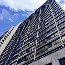
40 McCaul Street
Kensington-Chinatown, Toronto, M5T 1V9
Commute to Downtown Toronto
Daily errands do not require a car.
World-class public transportation.
Flat as a pancake, minimal bike lanes.
About your score
40 McCaul Street has a Walk Score of 100 out of 100. This location is a Walker’s Paradise so daily errands do not require a car.
40 McCaul Street is a three minute walk from the 501 QUEEN S.C. at the MCCAUL ST. stop.
This location is in the Kensington-Chinatown neighborhood in Toronto. Nearby parks include Butterfield Park, Grange Park Toronto and St. Patrick's Square.
Explore how far you can travel by car, bus, bike and foot from 40 McCaul Street.
40 McCaul Street is a Rider’s Paradise which means world-class public transportation. Car sharing is available from Zipcar.
Rail lines:
501 QUEEN S.C.
0.2 km
505 DUNDAS S.C.
0.3 km
1 LINE 1 (YONGE-UNIVERSITY)
0.3 km
Bus lines:
301 QUEEN N.C.
0.2 km
502 DOWNTOWNER
0.3 km
141 DOWNTOWN/MT.PLEASANT EXPRESS
0.3 km
144 DOWNTOWN/DON VALLEY EXPRESS
0.3 km
145 DOWNTOWN/HUMBER BAY EXPRESS
0.3 km
143 DOWNTOWN\BEACH EXPRESS
0.3 km
142 DOWNTOWN/AVENUE RD. EXPRESS
0.3 km
Car shares:
Bike shares:
40 McCaul Street is in the Kensington-Chinatown neighborhood. Kensington-Chinatown is the 3rd most walkable neighborhood in Toronto with a neighborhood Walk Score of 97.

OCAD University
Historic Campbell House Toronto
OCAD University


If you are using a screen reader or having trouble reading this website, please call Walk Score customer service at (253) 256-1634.
© 2024 Walk Score