Daily errands do not require a car.
World-class public transportation.
Flat as a pancake, some bike lanes.
About your score
This location has a Walk Score of 99 out of 100. This location is a Walker’s Paradise so daily errands do not require a car.
This location is a five minute walk from the 1 LINE 1 (YONGE-UNIVERSITY) at the MUSEUM STATION - SOUTHBOUND PLATFORM stop.
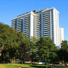
This location is in the Bay Street Corridor neighborhood in Toronto. Nearby parks include Queen's Park, Norman Jewison Park and George Hislop Park.
Explore how far you can travel by car, bus, bike and foot from this location.
This location is a Rider’s Paradise which means world-class public transportation. Car sharing is available from Zipcar.
Rail lines:
1 LINE 1 (YONGE-UNIVERSITY)
0.4 km
2 LINE 2 (BLOOR - DANFORTH)
0.4 km
306 CARLTON N.C.
0.7 km
506 CARLTON S.C.
0.7 km
Bus lines:
6 BAY
0.1 km
5 AVENUE ROAD
0.3 km
97 YONGE
0.3 km
320 YONGE NIGHT BUS
0.3 km
94 WELLESLEY
0.3 km
300 BLOOR-DANFORTH NIGHT BUS
0.3 km
Car shares:
Bike shares:
This location is in the Bay Street Corridor neighborhood. Bay Street Corridor is the most walkable neighborhood in Toronto with a neighborhood Walk Score of 99.

PATH
Queen's Park
Queen's Park


If you are using a screen reader or having trouble reading this website, please call Walk Score customer service at (253) 256-1634.
© 2024 Walk Score