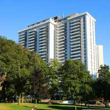
1 Massey Square
Some errands can be accomplished on foot.
World-class public transportation.
Flat as a pancake, excellent bike lanes.
About your score
1 Massey Square has a Walk Score of 68 out of 100. This location is Somewhat Walkable so some errands can be accomplished on foot.
1 Massey Square is an eight minute walk from the 2 LINE 2 (BLOOR - DANFORTH) at the VICTORIA PARK STATION - WESTBOUND PLATFORM stop.
This location is in the Crescent Town neighborhood in Toronto. Nearby parks include Taylor Creek Park, Dentonia Park and Donora Park.
Explore how far you can travel by car, bus, bike and foot from 1 Massey Square.
1 Massey Square is a Rider’s Paradise which means world-class public transportation. Car sharing is available from Zipcar.
Rail lines:
2 LINE 2 (BLOOR - DANFORTH)
0.5 km
LE Lakeshore East
1.2 km
ST Stouffville
1.2 km
503 KINGSTON RD. TRIPPER
1.8 km
Bus lines:
404 EAST YORK
0.2 km
23 DAWES
0.2 km
24 VICTORIA PARK
0.3 km
324 VICTORIA PARK NIGHT BUS
0.3 km
67 PHARMACY
0.5 km
12 KINGSTON ROAD
0.5 km
502 DOWNTOWNER
1.8 km
22 COXWELL
1.8 km
302 KINGSTON RD-McCOWAN NIGHT BUS
1.8 km
322 COXWELL NIGHT BUS
1.8 km
Car shares:
Bike shares:
1 Massey Square is in the Crescent Town neighborhood. Crescent Town is the 51st most walkable neighborhood in Toronto with a neighborhood Walk Score of 77.


If you are using a screen reader or having trouble reading this website, please call Walk Score customer service at (253) 256-1634.
© 2024 Walk Score