Almost all errands require a car.
A few nearby public transportation options.
Steep hills, excellent bike lanes.
About your score
This location has a Walk Score of 18 out of 100. This location is a Car-Dependent neighborhood so almost all errands require a car.
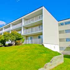
This location is in the Patterson neighborhood in Calgary. Nearby parks include Edworthy Park, Children's play park and Playground.
Explore how far you can travel by car, bus, bike and foot from this location.
This location has some transit which means a few nearby public transportation options.
Bus lines:
101 Coach Hill
0.1 km
453 West Springs
0.8 km
17 Spruce Cliff / Renfrew
0.9 km
104 Strathcona
0.9 km
This location is in the Patterson neighborhood. Patterson is the 138th most walkable neighborhood in Calgary with a neighborhood Walk Score of 41.


If you are using a screen reader or having trouble reading this website, please call Walk Score customer service at (253) 256-1634.
© 2024 Walk Score