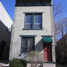
1610 Queen City Avenue
South Fairmont, Cincinnati, 45214
Commute to Downtown Cincinnati
Most errands require a car.
A few nearby public transportation options.
Very steep hills, minimal bike lanes.
About your score
1610 Queen City Avenue has a Walk Score of 33 out of 100. This location is a Car-Dependent neighborhood so most errands require a car.
This location is in the South Fairmont neighborhood in Cincinnati. Nearby parks include South Fairmount Playground, Saint Clair Heights Park and Crosley Field (historical).
Explore how far you can travel by car, bus, bike and foot from 1610 Queen City Avenue.
1610 Queen City Avenue has some transit which means a few nearby public transportation options. Car sharing is available from RelayRides.
Bus lines:
3342 Ferguson - Walnut Hills - Evanston
0.0 mi
6 Queen City - Westwood
0.0 mi
1732 Belmont - Beekman - Harrison
0.0 mi
3371 Ferguson - Bond Hill - Silverton
0.0 mi
3382 Ferguson - Delhi
0.0 mi
2431 Erie - Harrison - Glenway
0.0 mi
3335 Ferguson - Queen City
0.0 mi
1731 Belmont - Montana - Queen City
0.0 mi
4952 Ezzard Charles-West Price Hill
0.0 mi
3332 Ferguson - Harrison Ave
0.1 mi
Car shares:
1610 Queen City Avenue is in the South Fairmont neighborhood. South Fairmont is the 38th most walkable neighborhood in Cincinnati with a neighborhood Walk Score of 31.


If you are using a screen reader or having trouble reading this website, please call Walk Score customer service at (253) 256-1634.
© 2024 Walk Score