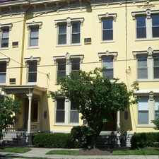
1677 Central Parkway
West End, Cincinnati, 45214
Commute to Downtown Cincinnati
Daily errands do not require a car.
Many nearby public transportation options.
Flat as a pancake, minimal bike lanes.
About your score
1677 Central Parkway has a Walk Score of 90 out of 100. This location is a Walker’s Paradise so daily errands do not require a car.
1677 Central Parkway is a four minute walk from the 100 Streetcar at the FINDLAY MARKET-ELM Station, Elm & Glass Alley stop.
This location is in the West End neighborhood in Cincinnati. Nearby parks include Hanna Playground, Laurel Playground and Mohawk Park.
Explore how far you can travel by car, bus, bike and foot from 1677 Central Parkway.
1677 Central Parkway has good transit which means many nearby public transportation options. Car sharing is available from Zipcar and RelayRides.
Rail lines:
100 Streetcar
0.1 mi
Bus lines:
20 Winton Rd - Tri - County
0.0 mi
5111 Duck Creek - Winton - West End
0.0 mi
6 Queen City - Westwood
0.0 mi
2141 Westwood Northern - Walnut Hills
0.0 mi
49 Queensgate - Fairmount
0.1 mi
3192 Clifton/McMillan - West End
0.1 mi
64 Glenway Crossing Westwood McMicken
0.1 mi
21 Westwood - Harrison Avenue
0.1 mi
4391 Seymour - Golf Manor - Montgomery
0.2 mi
3391 Ferguson - Mt Auburn - Vine
0.2 mi
Car shares:
Bike shares:
1677 Central Parkway is in the West End neighborhood. West End is the 3rd most walkable neighborhood in Cincinnati with a neighborhood Walk Score of 81.


If you are using a screen reader or having trouble reading this website, please call Walk Score customer service at (253) 256-1634.
© 2024 Walk Score