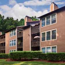
5511-5539 Butterfly Lane
Durham, North Carolina, 27707
Commute to Downtown Chapel Hill
Most errands require a car.
It is possible to get on a bus.
Mostly flat, minimal bike lanes.
About your score
5511-5539 Butterfly Lane has a Walk Score of 32 out of 100. This location is a Car-Dependent neighborhood so most errands require a car.
This location is in Durham. Nearby parks include New Hope Creek and West Chapel Hill Road Site.
Explore how far you can travel by car, bus, bike and foot from 5511-5539 Butterfly Lane.
5511-5539 Butterfly Lane has minimal transit which means it is possible to get on a bus.
Bus lines:
10 DATA - Woodcroft & New Hope Commons
0.4 mi
400 Durham-Patterson Pl-Chapel Hill
0.7 mi
d CHT - Culbreth Road/Franklin Street/Eastowne
0.9 mi
dsat CHT - Greenbridge/University Mall/Eastowne
0.9 mi
dx CHT - Old Durham/Old Sterling/Sage Road
0.9 mi
This location is in the city of Durham, NC. Durham has an average Walk Score of 29 and has 228,330 residents.

The Pizzeria
Trinity Commons at Erwin
Courtyard Durham Research Triangle Park


If you are using a screen reader or having trouble reading this website, please call Walk Score customer service at (253) 256-1634.
© 2024 Walk Score