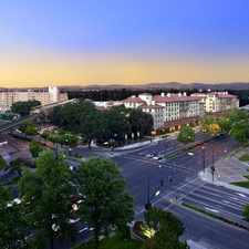
Iron Horse Regional Trail
Walnut Creek, California, 94596
Commute to Downtown Walnut Creek
Some errands can be accomplished on foot.
About your score
Iron Horse Regional Trail has a Walk Score of 59 out of 100. This location is Somewhat Walkable so some errands can be accomplished on foot.
This location is in Walnut Creek. Nearby parks include Howe Homestead Park, Howe Homestead Park and Larieu Park.
Explore how far you can travel by car, bus, bike and foot from Iron Horse Regional Trail.
Rail lines:
Pittsburg/Bay Point - SFIA/Millbrae San Francisco Int'l Airport
1.5 mi
Bus lines:
5 Creekside/BART Walnut Creek
0.1 mi
321 BART Walnut Creek/San Ramon
0.2 mi
21 BART Walnut Creek/San Ramon
0.2 mi
2 Rudgear/BART Walnut Creek
0.3 mi
4 Broadway Plaza/BART Walnut Creek
0.4 mi
Car shares:
This location is in the city of Walnut Creek, CA. Walnut Creek has an average Walk Score of 38 and has 64,173 residents.

Walnut Creek Library Foundation
Ebar
The Cheesecake Factory


If you are using a screen reader or having trouble reading this website, please call Walk Score customer service at (253) 256-1634.
© 2024 Walk Score