Clinton Street
Most errands require a car.
A few nearby public transportation options.
About your score
Clinton Street has a Walk Score of 41 out of 100. This location is a Car-Dependent neighborhood so most errands require a car.
This location is in Brampton. The closest park is McKinney Parkette.
Explore how far you can travel by car, bus, bike and foot from Clinton Street.
Clinton Street has some transit which means a few nearby public transportation options.
Bus lines:
25 Edenbrook
0.4 km
3 McLaughlin
0.4 km
24 Van Kirk
0.6 km
This location is in the city of Brampton, ON. Brampton has an average Walk Score of 48 and has 523,911 residents.

Mount Pleasant GO Station Rail
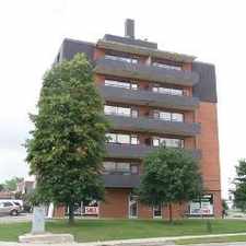
4-20 Duxford Street
4-20 Duxford Street


If you are using a screen reader or having trouble reading this website, please call Walk Score customer service at (253) 256-1634.
© 2024 Walk Score