


Search for apartments in San Francisco or check out apartments in other San Francisco neighborhoods. Links will open on our partner site Redfin.com.
- Bernal Heights, San Francisco apartments for rent
- Cow Hollow, San Francisco apartments for rent
- Dogpatch, San Francisco apartments for rent
- Glen Park, San Francisco apartments for rent
- Hayes Valley, San Francisco apartments for rent
- Inner Richmond, San Francisco apartments for rent
- Inner Sunset, San Francisco apartments for rent
- Marina District, San Francisco apartments for rent
- Mission Bay, San Francisco apartments for rent
- Mission District, San Francisco apartments for rent
- Nob Hill, San Francisco apartments for rent
- Noe Valley, San Francisco apartments for rent
- North Beach, San Francisco apartments for rent
- Outer Richmond, San Francisco apartments for rent
- Outer Sunset, San Francisco apartments for rent
- Pacific Heights, San Francisco apartments for rent
- Potrero Hill, San Francisco apartments for rent
- Presidio Heights, San Francisco apartments for rent
- Russian Hill, San Francisco apartments for rent
- Sunset District, San Francisco apartments for rent


 This is the view from the Golden Gate Bridge. The Presidio of San Francisco is a park and former military base on the northern tip of the San Francisco Peninsula in San Francisco. It has 1480 acres and more than 500 historic buildings. This is the view from the Golden Gate Bridge. Nice open spaces, the park is dog friendly, perfect place for a picnic and just getting away from it all. #SanFrancisco, #PresidioPark, #Parks, #MilitaryFort, #Walking, #Jogging, #Nature, #Picnics, #HistoricalBuildings, #Museum


 The sea lions camped out in PIER 39′s West Marina have been endearingly coined The PIER’s “Sea Lebrities.” The boisterous pinnipeds started arriving in droves in January 1990, shortly after the 1989 Loma Prieta earthquake.
#Pier39, #SanFrancisco, #SoManyTimesToSeeInSanFrancisco, #WeLoveSanFrancisco
The sea lions camped out in PIER 39′s West Marina have been endearingly coined The PIER’s “Sea Lebrities.” The boisterous pinnipeds started arriving in droves in January 1990, shortly after the 1989 Loma Prieta earthquake.
#Pier39, #SanFrancisco, #SoManyTimesToSeeInSanFrancisco, #WeLoveSanFrancisco


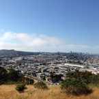
 The famous (or infamous) Rope Swing of Billy Goat Hill Park. The initial 5 feet from the ground swing can easily turn into a 15-20+ foot drop. Not for faint of heart. But you can get really cool photos with the city background as you swing.


Norma and Kyle - BLU DOT Realty Group
on Sutro Baths