

Harrison Street

Most errands can be accomplished on foot.

Many nearby public transportation options.

Some bike infrastructure.

Harrison Street has a Walk Score of 88 out of 100. This location is Very Walkable so most errands can be accomplished on foot.
This location is in the Adams Point neighborhood in Oakland. Nearby parks include Oak Glen Park, Oak Park and Glen Echo Creek Parklet.

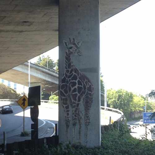
An unexplained piece of street art in Oakland, the Freeway Giraffes are always watching out for dangerous drivers.
Explore how far you can travel by car, bus, bike and foot from Harrison Street.
Harrison Street has good transit which means many nearby public transportation options.
Rail lines:
Red-N SFO / SF / Richmond
0.9 mi
Orange-N OAK Airport / Richmond
0.9 mi
Yellow-N San Francisco / Antioch
0.9 mi
Yellow-S San Francisco International Airport
0.9 mi
Red-S SF / SFO Airport / Millbrae
0.9 mi
Orange-S OAK Airport / Berryessa/North San Jose
0.9 mi
Bus lines:
57 40th St. - MacArthur
0.0 mi
658 Skyline - Bret Harte - MacArthur
0.0 mi
657 Oak High - Oak Tech - MacArthur
0.0 mi
653 Montera - MacArthur
0.0 mi
P Piedmont - Oakland Ave. Transbay
0.0 mi
33 Piedmont - Harrison - Park Blvd.
0.0 mi
Harrison Street is in the Adams Point neighborhood. Adams Point is the 24th most walkable neighborhood in Oakland with a neighborhood Walk Score of 89.
Moving to Oakland from another city? View our moving to Oakland guide.
If you are using a screen reader or having trouble reading this website, please call Walk Score customer service at (253) 256-1634.
© 2026 Walk Score
Sean Delizo