
110 10th Street
Daily errands do not require a car.
Transit is convenient for most trips.
Biking is convenient for most trips.

110 10th Street has a Walk Score of 97 out of 100. This location is a Walker’s Paradise so daily errands do not require a car.
110 10th Street is a two minute walk from the Blue-S OAK Airport / SF / Daly City, the Green-S OAK Airport / SF / Daly City and the Orange-N OAK Airport / Richmond at the Lake Merritt stop.
This location is in Oakland. Nearby parks include Madison Park, 12th Street Lakeside Park and Lincoln Square.

Outside of the Oakland Museum a landmark sculpture indicates where the tunnel to leave the Civic Center area
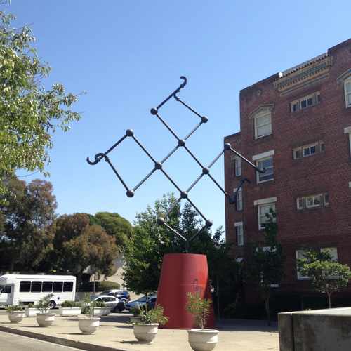

The Oakland Museum always has wonderful galleries and fun, participatory events for children. Also, it's within walking distance of BART

Emily Pankey
Explore how far you can travel by car, bus, bike and foot from 110 10th Street.
110 10th Street has excellent transit which means transit is convenient for most trips.
Rail lines:
Blue-N SF / OAK Airport / Dublin/Pleasanton
0.1 mi
Orange-S OAK Airport / Berryessa/North San Jose
0.1 mi
Green-N Berryessa/North San Jose
0.1 mi
Blue-S OAK Airport / SF / Daly City
0.1 mi
Orange-N OAK Airport / Richmond
0.1 mi
Green-S OAK Airport / SF / Daly City
0.1 mi
CC Capitol Corridor
0.5 mi
Red-S SF / SFO Airport / Millbrae
0.5 mi
Yellow-N San Francisco / Antioch
0.5 mi
Yellow-S San Francisco International Airport
0.5 mi
Bus lines:
88 Sacramento - Market
0.0 mi
611 Westlake Middle - 14th Ave.
0.0 mi
96 Alameda Pt. - 14th Ave. - Dimond
0.0 mi
29 Hollis - Peralta - Lakeshore
0.1 mi
1 International - E. 14th
0.1 mi
40 Foothill - Bancroft - Bay Fair
0.1 mi
33 Piedmont - Harrison - Park Blvd.
0.1 mi
801 Intl - Mission All Nighter
0.1 mi
840 Foothill - Eastmont All Nighter
0.1 mi
62 7th St. - San Antonio - 23rd Av.
0.1 mi
This location is in the city of Oakland, CA. Oakland has an average Walk Score of 75 and has 390,724 residents.

Fitzgerald Park
Martin Luther King Super Stop
Martin Luther King, Junior Elementary School
If you are using a screen reader or having trouble reading this website, please call Walk Score customer service at (253) 256-1634.
© 2026 Walk Score
Emily Pankey