3860 Camels Ridge Lane
Kissing Camels, Colorado Springs, 80904
Commute to Downtown Colorado Springs
Almost all errands require a car.
It is possible to get on a bus.
Mostly flat, minimal bike lanes.
About your score
3860 Camels Ridge Lane has a Walk Score of 5 out of 100. This location is a Car-Dependent neighborhood so almost all errands require a car.
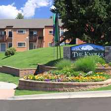
This location is in the Kissing Camels neighborhood in Colorado Springs.
Explore how far you can travel by car, bus, bike and foot from 3860 Camels Ridge Lane.
3860 Camels Ridge Lane has minimal transit which means it is possible to get on a bus.
Bus lines:
2 CENTENNIAL BLVD - G.O.G. Rd.
0.5 mi
14 Chestnut St - G.O.G. Rd
0.7 mi
34 GOG/AUSTIN BLUFFS PKWY
0.7 mi
17 19TH STREET/FILLMORE
0.9 mi
3860 Camels Ridge Lane is in the Kissing Camels neighborhood. Kissing Camels is the 59th most walkable neighborhood in Colorado Springs with a neighborhood Walk Score of 11.
Moving to Colorado Springs from another city? View our moving to Colorado Springs guide.


If you are using a screen reader or having trouble reading this website, please call Walk Score customer service at (253) 256-1634.
© 2024 Walk Score