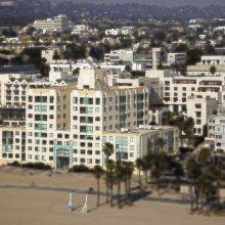
737 Raymond Avenue
Most errands can be accomplished on foot.
Many nearby public transportation options.
Mostly flat, excellent bike lanes.
Score Details
737 Raymond Avenue has a Walk Score of 84 out of 100. This location is Very Walkable so most errands can be accomplished on foot.
This location is in Santa Monica. Nearby parks include Ozone Park, Los Amigos Park and Joslyn Park.
Nearby schools include Olympic High (Continuation) High School, John Muir Elementary School and Santa Monica Alternative (K-8) School.
The closest grocery stores are Albertsons, Big Squeeze and Whole Foods Market.
Nearby coffee shops include The Novel Cafe, 212 pier and Amelia's. There are 54 restaurants within a 15 minute walk including McDonald's, Lattitude Thai Restaurant and Pancho's Tacos.
737 Raymond Avenue is near Ozone Park, Joslyn Park and Hotchkiss Park.
There are excellent bike lanes and the terrain is mostly flat. 737 Raymond Avenue is a Biker’s Paradise, daily errands can be accomplished on a bike.
Explore how far you can travel by car, bus, bike and foot from 737 Raymond Avenue.
737 Raymond Avenue has good transit which means many nearby public transportation options. Car sharing is available from RelayRides and Getaround.
Bus lines:
3 Montana Ave - Lincoln Blvd - Lax
0.1 mi
8 Ocean Park Blvd - Ucla
0.2 mi
Car shares:
This location is in the city of Santa Monica, CA. Santa Monica has an average Walk Score of 78 and has 89,736 residents.

Ocean / Santa Monica
Santa Monica Pier
Palisades Park Rose Garden


If you are using a screen reader or having trouble reading this website, please call Walk Score customer service at (253) 256-1634.
© 2024 Walk Score