Walk Score Logo
Go
Locate me

Living in West End Atlanta

West End is the 26th most walkable neighborhood in Atlanta with 4,291 residents.

West End has good public transportation and is somewhat bikeable.

Nearby neighborhoods: Harris Chiles, Ashview Heights, Oakland City, Adair Park, Westview, Atlanta University Center and Mozley Park.

Nearby West End Apartments on Redfin

71 Walk Score of West End, Atlanta, GA

West End is Very Walkable

Most errands can be accomplished on foot.

Walk Score Map

25
100
Photo of Howell Park in West End, Atlanta

Howell Park

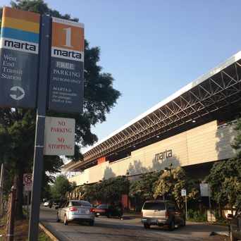
Photo of WEST END STATION in West End, Atlanta

WEST END STATION

Most errands can be accomplished on foot in West End Atlanta.

West End is the 26th most walkable neighborhood in Atlanta with a Walk Score of 71.

Find apartments in Atlanta's most walkable neighborhoods: Georgia State University, Buckhead Village and Sweet Auburn.

West End Atlanta Apartments for Rent

West End Neighborhood Ranking

Compare West End to other Atlanta neighborhoods.

Rank

#

Name

Walk Score

Transit Score

Bike Score

Population

24 Buckhead Forest 73 44 48 2,436
25 Lindbergh - Morosgo 72 59 41 4,603
26 West End 71 54 65 4,291
27 Atlanta University Center 70 57 58 5,910
28 Berkeley Park 70 35 61 1,407

Moving to Atlanta from another city?

Eating & Drinking

There are about 64 restaurants, bars and coffee shops in West End.

People in West End can walk to an average of 2 restaurants, bars and coffee shops in 5 minutes.

Restaurant Choices Map

= More Choices

thumbnail for Howell ParkHowell Park is the largest public green space in West End and contains playgrounds and trails which allow people of all ages to enjoy this oasis in the city.

David Danger Howell
on Howell Park

54 Transit Score of West End, Atlanta, GA

West End has Good Transit

Many nearby public transportation options. Find West End Atlanta apartments for rent on Redfin.

Public Transit Routes

West End has good public transportation and about 10 bus and 2 subway lines passing through it.

Transit Time

The map above shows how far you can travel in 30 minutes from West End on public transit.

65 Bike Score of West End, Atlanta, GA

West End is Bikeable

Some bike infrastructure.

25
100
Bike
Score

     o__
    _.>/ _
___(_)_\(_)___
          
Bike
Lanes

________________
 __  __  __  __
________________
          
Hills
          _
         / \
   _   _/   \
__/ \_/      \__
          
Bike
Commuters
              _
             |_|
/\           |_|
[]...........|_|
          

Photo of St. Anthony Of Padua Catholic Church in West End, Atlanta

St. Anthony Of Padua Catholic Church

Photo of West Hunter Street Baptist Church in West End, Atlanta

West Hunter Street Baptist Church

Photo of St. Anthony Of Padua Catholic Church in West End, Atlanta

St. Anthony Of Padua Catholic Church

Photo of West Hunter Street Baptist Church in West End, Atlanta

West Hunter Street Baptist Church

thumbnail for WEST END STATIONWest End Marta Station provides local access to rail and bus routes which connect the community to the Greater Atlanta area.

David Danger Howell
on WEST END STATION

thumbnail for St. Anthony Of Padua Catholic ChurchThis neighborhood institution is one of the oldest churches in the area. Having existed since the 1940s it promotes strong ties to the community through numerous outreach activities.

David Danger Howell
on St. Anthony Of Padua Catholic Church

Walk Score Professional

Real Estate

Walk Score Neighborhood Map

Add Walk Score, Bike Score, and Transit Score to your rental and for sale properties with the Walk Score Widget.

Software Developers

Walk Score APIs

Build apps with Walk Score, public transit data, and commute and travel times via Walk Score APIs.

Data and Analysis

Walk Score Data and Research

Use Walk Score data for real estate, public health, finance, and urban planning research and analysis.