

Abilene has an average Walk Score of 31 with 117,063 residents.
Abilene does not have many bike lanes.
The most walkable Abilene neighborhoods are Sayles Boulevard Area, Original Town North and Over Place Area.
Most errands require a car.


Courtyard by Marriott Abilene Southwest/Abilene Mall South

Residence Inn by Marriott Abilene
Most errands require a car in Abilene.
Rank # | Name | Walk Score | Transit Score | Bike Score |
|---|---|---|---|---|
| 1 | Sayles Boulevard Area | 58 | - | 46 |
| 2 | Original Town North | 52 | - | 46 |
| 3 | Over Place Area | 51 | - | 42 |
| 4 | Original Town South | 50 | - | 46 |
| 5 | Red Bud Area | 47 | - | 39 |
| 6 | Elmwood Area | 46 | - | 40 |
| 7 | Cobb Park Area | 46 | - | 43 |
| 8 | River Oaks-Brookhollow | 42 | - | 38 |
| 9 | South Treadaway Area | 39 | - | 37 |
| 10 | Park Central Area | 37 | - | 36 |
| 11 | North College | 36 | - | 42 |
| 12 | Abilene Heights Area | 34 | - | 53 |
| 13 | Westwood Richland | 33 | - | 37 |
| 14 | Chimney Rock Area | 26 | - | 39 |
| 15 | Sears Park Area | 25 | - | 35 |
| 16 | Lytle Area | 9 | - | 28 |
| 17 | Buck Creek Area | 9 | - | 30 |
| 18 | Far Southside | 6 | - | 26 |
There are about 282 restaurants, bars and coffee shops in Abilene.
People in Abilene can walk to an average of 0.2 restaurants, bars and coffee shops in 5 minutes.
Minimal bike infrastructure.
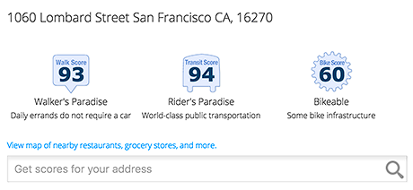
Add Walk Score, Bike Score, and Transit Score to your rental and for sale properties with the Walk Score Widget.

Build apps with Walk Score, public transit data, and commute and travel times via Walk Score APIs.

Use Walk Score data for real estate, public health, finance, and urban planning research and analysis.
If you are using a screen reader or having trouble reading this website, please call Walk Score customer service at (253) 256-1634.
© 2026 Walk Score


