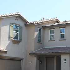
316 Randy Lane
316 Randy Lane has a Walk Score of 44 out of 100. This location is a Car-Dependent neighborhood so most errands require a car.
This location is in the Central Perris neighborhood in Perris. Nearby parks include Banta Beatty Park and Woodhaven Park.
Explore how far you can travel by car, bus, bike and foot from 316 Randy Lane.
Rail lines:
91/PVL 91/Perris Valley Line
1.0 mi
Bus lines:
30 Weston&Strohm/PerrisTrnstCntr/May Ranch
0.1 mi
19 MoValleyMall/PerrisTrnstCntr
0.4 mi
19F MoValleyMall/PerrisTrnstCntr
0.4 mi
27 GalleriaTyler/PerrisTrnstCntr/HemMall/Flor&Linc
0.4 mi
Car shares:
316 Randy Lane is in the Central Perris neighborhood. Central Perris is the 2nd most walkable neighborhood in Perris with a neighborhood Walk Score of 29.




If you are using a screen reader or having trouble reading this website, please call Walk Score customer service at (253) 256-1634.
© 2026 Walk Score