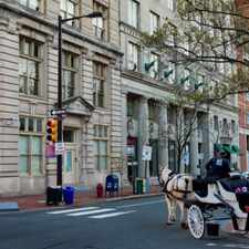
333 Vine Street
Most errands can be accomplished on foot.
Many nearby public transportation options.
About your score
333 Vine Street has a Walk Score of 71 out of 100. This location is Very Walkable so most errands can be accomplished on foot.
333 Vine Street is a nine minute walk from the Riverline Light Rail at the COOPER ST/RUTGERS UNIV stop.
This location is in the Pyne Poynt neighborhood in Camden. Nearby parks include Wiggins Park, Penn Treaty Park and Penn Treaty Park.
Explore how far you can travel by car, bus, bike and foot from 333 Vine Street.
333 Vine Street has good transit which means many nearby public transportation options. Car sharing is available from Zipcar and RelayRides.
Rail lines:
Riverline Light Rail
0.4 mi
PATCO Westbound to Philadelphia
0.5 mi
PATCO Eastbound to Lindenwold
0.5 mi
15 63rd-Girard to Richmond-Westmorelnd
1.1 mi
MFL Frankford TC to 69th St TC
1.2 mi
Bus lines:
452
0.1 mi
460
0.1 mi
419
0.3 mi
551
0.4 mi
406
0.4 mi
409
0.4 mi
412
0.4 mi
414
0.4 mi
313
0.4 mi
417
0.4 mi
Car shares:
333 Vine Street is in the Pyne Poynt neighborhood. Pyne Poynt is the 13th most walkable neighborhood in Camden with a neighborhood Walk Score of 69.


If you are using a screen reader or having trouble reading this website, please call Walk Score customer service at (253) 256-1634.
© 2025 Walk Score