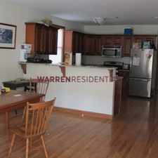
67 Myrtle Street
Most errands can be accomplished on foot.
Score Details
67 Myrtle Street has a Walk Score of 86 out of 100. This location is Very Walkable so most errands can be accomplished on foot.
This location is in Waltham. Nearby parks include Chemistry Station Park, Richard Landry Park and Riverwalk Park.
Explore how far you can travel by car, bus, bike and foot from 67 Myrtle Street.
Rail lines:
Fitchburg/South Acton Line
0.6 mi
Framingham/Worcester Line
1.2 mi
Bus lines:
556
0.1 mi
170
0.2 mi
554
0.2 mi
553
0.2 mi
505
0.2 mi
Car shares:
View all Waltham apartments on a map.

Popular apartment searches include single family, pool and hardwood floor.
This location is in the city of Waltham, MA. Waltham has an average Walk Score of 49 and has 60,632 residents.
Learn More About Waltham


If you are using a screen reader or having trouble reading this website, please call Walk Score customer service at (253) 256-1634.
© 2026 Walk Score