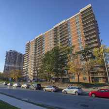
69 Bloomsbury Avenue
Almost all errands require a car.
A few nearby public transportation options.
Score Details
69 Bloomsbury Avenue has a Walk Score of 10 out of 100. This location is a Car-Dependent neighborhood so almost all errands require a car.
This location is in Brampton.
Nearby schools include Treeline Public School, Holy Spirit Catholic Elementary School and Fairlawn Public School.
The closest grocery stores are Sab Ka Bazaar, M&M Meat Shops and Edible Arrangements.
Nearby coffee shops include Tim Hortons and McDonald's. Nearby restaurants include Caribbean Delite, Pizza Depot and MDS Academy of Food and Driver's Training.
69 Bloomsbury Avenue is near James and Margaret McGie Park, Lillie Roberts Park and Carabram Park.
Explore how far you can travel by car, bus, bike and foot from 69 Bloomsbury Avenue.
69 Bloomsbury Avenue has some transit which means a few nearby public transportation options.
Bus lines:
31 McVean
0.3 km
23 Sandalwood
1.2 km
5 Bovaird
1.2 km
30 Airport Road
1.2 km
View all Brampton apartments on a map.

Popular apartment searches include hardwood floor, furnished and fireplace.
This location is in the city of Brampton, ON. Brampton has an average Walk Score of 48 and has 523,911 residents.
Mount Pleasant GO Station Rail
4-20 Duxford Street
4-20 Duxford Street

If you are using a screen reader or having trouble reading this website, please call Walk Score customer service at (253) 256-1634.
© 2026 Walk Score