


Search for apartments in Denver or check out apartments in other Denver neighborhoods. Links will open on our partner site Redfin.com.
- Aspen, Denver apartments for rent
- Berkeley, Denver apartments for rent
- Capitol Hill, Denver apartments for rent
- Central Park, Denver apartments for rent
- Cherry Creek, Denver apartments for rent
- Cherry Hills, Denver apartments for rent
- Congress Park, Denver apartments for rent
- Downtown Denver, Denver apartments for rent
- Green Valley Ranch, Denver apartments for rent
- Henderson, Denver apartments for rent
- Highland, Denver apartments for rent
- Hilltop, Denver apartments for rent
- Lowry, Denver apartments for rent
- Park Hill, Denver apartments for rent
- Platt Park, Denver apartments for rent
- Reunion, Denver apartments for rent
- Sloan Lake, Denver apartments for rent
- Sunnyside, Denver apartments for rent
- University Hills, Denver apartments for rent
- Washington Park, Denver apartments for rent


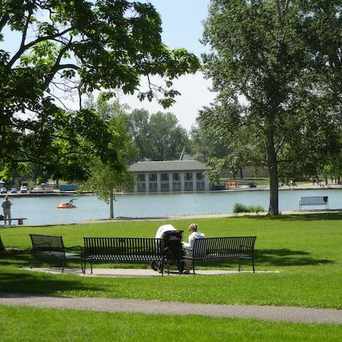
 Denver's best park. Cycling, running, gardens, lakes, soccer fields, barbecue. A perfect retreat in the heart of Denver.


 Dancer's in the Park on beautiful night.


 With some of the most beautiful architecture in the city, the cathedral (located on Colfax just east of the Capitol building) is a must see whether you're just visiting or have lived here your whole life. And photographers, bring your cameras at sunrise or sunset for some almost guaranteed awesome shots! #CapitolHill #Uptown


Emily Foos
on Auraria Campus