
1961 Centre Street
Most errands can be accomplished on foot.
A few nearby public transportation options.
Minimal bike infrastructure.

1961 Centre Street has a Walk Score of 89 out of 100. This location is Very Walkable so most errands can be accomplished on foot.
1961 Centre Street is a four minute walk from the Needham Line at the West Roxbury stop.
This location is in Boston. Nearby parks include Billings Field, West Roxbury Parkway and Hynes Field.

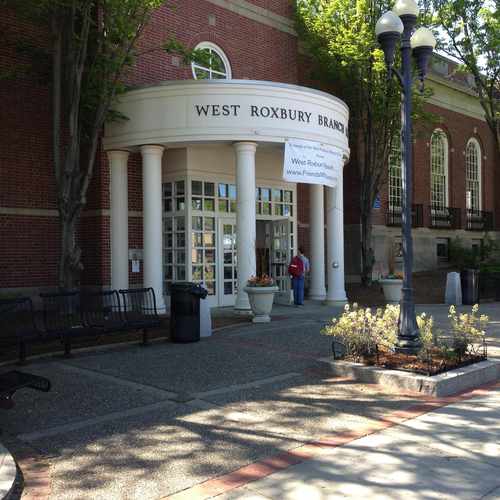
This is west roxburys public library it's beautiful. Multi floors. Kids room. Benches outdoors for outdoor seating. Great library
Explore how far you can travel by car, bus, bike and foot from 1961 Centre Street.
1961 Centre Street has some transit which means a few nearby public transportation options.
Rail lines:
Needham Line
0.2 mi
Bus lines:
37 Baker Street & Vermont Street - Forest Hills Station
0.0 mi
36 Millennium Park or VA Hospital - Forest Hills Station
0.0 mi
35 Dedham Mall or Stimson Street - Forest Hills Station
0.0 mi
Needham Line Shuttle Newton Highlands - Forest Hills
0.2 mi
Needham Line Shuttle Needham Heights - Forest Hills
0.2 mi
This location is in the city of Boston, MA. Boston has an average Walk Score of 83 and has 617,594 residents.

Mission Hill Playground
Park Street Station
Castle At Park Plaza Hotel
If you are using a screen reader or having trouble reading this website, please call Walk Score customer service at (253) 256-1634.
© 2026 Walk Score
Voula Paras