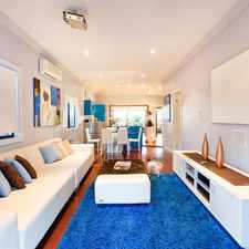
48 Morley Street

Some errands can be accomplished on foot.

Many nearby public transportation options.
About your score
48 Morley Street has a Walk Score of 68 out of 100. This location is Somewhat Walkable so some errands can be accomplished on foot.
48 Morley Street is a 16 minute walk from the BRIP Brisbane City - Ipswich line, the CAIP Caboolture line - Ipswich line and the CARW Caboolture line - Rosewood line at the Auchenflower, platform 3 stop.
This location is in the Toowong neighborhood in Brisbane. Nearby parks include Quinn Park, Toowong Memorial Park and Anzac Park.
Explore how far you can travel by car, bus, bike and foot from 48 Morley Street.
48 Morley Street has good transit which means many nearby public transportation options.
Rail lines:
CARW Caboolture line - Rosewood line
1.0 km
CAIP Caboolture line - Ipswich line
1.0 km
BRIP Brisbane City - Ipswich line
1.0 km
RWBR Rosewood line - Brisbane City
1.0 km
SPCA Springfield line - Caboolture line
1.0 km
IPCA Ipswich line - Caboolture line
1.0 km
SPBR Springfield line - Brisbane City
1.0 km
IPBR Ipswich line - Brisbane City
1.0 km
SPNA Springfield line - Nambour line
1.0 km
RWCA Rosewood line - Caboolture line
1.0 km
Bus lines:
470 Toowong - Teneriffe Ferry
0.1 km
P457 Riverhills - City Precincts Pre-Paid Rocket
0.3 km
P459 Riverhills - City Precincts Pre-Paid Rocket
0.3 km
P458 Mt Ommaney - City Precincts Pre-Paid Rocket
0.3 km
431 Kenmore South - City Rocket
0.4 km
446 Kenmore - City Rocket
0.4 km
N449 Valley - Riverhills NightLink via Indooroopilly
0.5 km
598 Great Circle Line Anti-Clockwise
0.5 km
599 Great Circle Line Clockwise
0.5 km
416 Duke Street - City
0.5 km
Bike shares:
View all Toowong apartments on a map.

Popular apartment searches include pool, furnished and top floor.
48 Morley Street is in the Toowong neighborhood. Toowong is the 34th most walkable neighborhood in Brisbane with a neighborhood Walk Score of 74.
Corner Store Cafe
Corner Store Cafe
Woolworths Toowong




If you are using a screen reader or having trouble reading this website, please call Walk Score customer service at (253) 256-1634.
© 2026 Walk Score