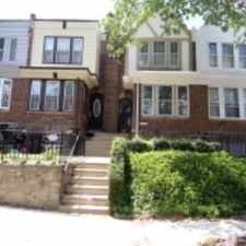
6110 Belden St
Most errands can be accomplished on foot.
Many nearby public transportation options.
Flat as a pancake, some bike lanes.
Score Details
6110 Belden St has a Walk Score of 82 out of 100. This location is Very Walkable so most errands can be accomplished on foot.
This location is in the Oxford Circle neighborhood in Philadelphia. Nearby parks include Tarken Playground, Max Myers Playground and Max Myers Playground.
Nearby schools include Carnell Laura H School, Oxford Circle Baptist Church and Glading Memorial Presbyterian.
The closest grocery stores are Super Deli, Don Pedro Meats & Market and Charlie's Grocery.
Nearby coffee shops include Dunkin' Donuts, Dunkin' Donuts and C1 Bakery & Cafe. Nearby restaurants include Castor Pizza, Xin Xing House and Burger King.
6110 Belden St is near Wissinoming Park, Pennypack Park and McPherson Square.
There are some bike lanes and the terrain is flat as a pancake. 6110 Belden St is bikeable, there is some bike infrastructure.
Explore how far you can travel by car, bus, bike and foot from 6110 Belden St.
6110 Belden St has good transit which means many nearby public transportation options. Car sharing is available from RelayRides and Zipcar.
Rail lines:
MFL Frankford TC to 69th St TC
1.0 mi
Fox Chase Line Fox Chase Line
1.4 mi
Bus lines:
59 Castor-Bustleton to Arrott TC
0.2 mi
24 Southampton/Rockledge to FTC
0.3 mi
19 Torresdale Station to FTC
0.3 mi
67 Frank Mills Mall & Bustleton to FTC
0.3 mi
1 Parx Casino to 54th-City
0.3 mi
Car shares:
6110 Belden St compared to all of Philadelphia.
Lower crime area.
Lower crime area.
How do you feel walking near 6110 Belden St?
Day:
Night:
Thanks for your feedback!
View all Oxford Circle apartments on a map.

6110 Belden St is in the Oxford Circle neighborhood. Oxford Circle is the 41st most walkable neighborhood in Philadelphia with a neighborhood Walk Score of 78.
Moving to Philadelphia from another city? View our moving to Philadelphia guide.
Oxford Circle Produce Center
Magee Av & Horrocks St
Womrath Park


If you are using a screen reader or having trouble reading this website, please call Walk Score customer service at (253) 256-1634.
© 2025 Walk Score