


Search for apartments in Baltimore or check out apartments in other Baltimore neighborhoods. Links will open on our partner site Redfin.com.
- Bolton Hill, Baltimore apartments for rent
- Brooklyn, Baltimore apartments for rent
- Canton, Baltimore apartments for rent
- Charles Village, Baltimore apartments for rent
- Federal Hill Park, Baltimore apartments for rent
- Federal Hill-Montgomery, Baltimore apartments for rent
- Fells Point, Baltimore apartments for rent
- Guilford, Baltimore apartments for rent
- Hampden, Baltimore apartments for rent
- Homeland, Baltimore apartments for rent
- Lauraville, Baltimore apartments for rent
- Locust Point, Baltimore apartments for rent
- Morrell Park, Baltimore apartments for rent
- Mount Vernon, Baltimore apartments for rent
- Mount Washington, Baltimore apartments for rent
- Patterson Park, Baltimore apartments for rent
- Remington, Baltimore apartments for rent
- Riverside, Baltimore apartments for rent
- Roland Park, Baltimore apartments for rent
- Washington Village-Pigtown, Baltimore apartments for rent


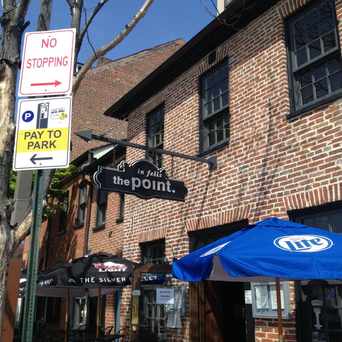


 Typical small Baltimore Street. A lot of houses in Upper Fells Point have actually improved over years.


 An artisanal market that has gone through many transformations to get to its current state. Everything from Atwaters deli, to Ceriello's Italian market to the Grand Cru this place has some really great specialty shops. And during te warmer months they sponsor an out door concert series which gets crowded so get there early.


 Iconic Lexington Market, a must see in Downtown. Stop by for fresh produce, seafood, and prepared food. Not only is this a great place to grab a bite but a must see historical site


J L
on Howard P. Rawlings Conservatory & Botanic Gardens